Recorded Change Overtime
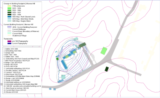
The records associated with the existing Monroe Hill site and landscape date back to the colonial period. While the name, Monroe Hill, first appeared during the Civil War, the site was part of a 400-acre patent purchased by Abraham Lewis in 1735. The current name of the site derives from James Monroe's acquisition of the 800-acre plot in 1789. In February of 1789 Monroe wrote to Jefferson describing "the land," as "tolerably good and great art in wood."Monroe planned to develop his "lower plantation," consisting of Monroe Hill. Several structures were purchased by the spring of 1791, and a fire insurance policy from 1800 describes three structures, two of which are identical in size and plan. A drawing tracks the change in the building footprint overtime, mapping out chronological timeline of the development of the property from the turn of the eighteenth century to present day.
There were a series of three major building campaigns, that field work and archival records support: Phase one dates from the 1790s to about 1819, Phase two likely mid 1820s: from about 1822 to 1823, another campaign likely occurred in the 1840s based on sources from George Spooner, and a final major early campaign in the 1860s.
Circumstances surrounding Monroe's public appointment and private finances forced him to sell 670 acres of his property to Kemp Catlett in 1806 - who later sold the land the John M. Perry. In terms of outbuildings we know that under Perry's occupation the property included a frame smoke house, an ice house, and a well. These buildings are believed to have existed during Catlett and Nichols occupation.
A letter from Jefferson to Brockenbrough, the University Proctor, in 1825, alluded to the landscape of Monroe Hill. In contrast to the Academical Village, Monroe Hill was considered more favorable for a family residence due to its distance from the bustle of student life and its outbuildings and surrounding land which could support the Brockenbrough household. Such assets attributed to the site’s nineteenth-century landscape are important to consider when reviewing Monroe Hill in its entirety and within the context of the University.
The University’s water system also helps to clarify Monroe Hill’s landscape timeline. The earliest water supply scheme designed in 1824 channeled water from Observatory Hill down to the University’s principal buildings via a network of wooden pipes and stored in cisterns on the West Lawn. Brockenbrough notes the proximity of wooden pipes to the stables and outbuildings at Monroe Hill. These wooden pipes, mentioned by Brockenbrough likely date to Jefferson's improvements to the early water system. Jefferson’s design featured log pipes that were dug deeper into the ground for added security, as to solve the leakages of the 1824 supply scheme. Thus, as early as the nineteenth century it is the clear that the landscape at Monroe Hill was altered to fit the needs of both its residences, as well as the systems and needs of the greater University. Payments made to Andrew Zigler for "repairs to pump," recorded in the Proctor's Journal in 1833 support earlier evidence of such alterations to the landscape. An 1855 map, drafted by Ellot shows the location of water pipes, cisterns, as well as existing buildings and their relationship to the water system. Mention of the cistern appears again in the 1860s when Thomas Farrar a freed black worker was aid thirty-five dollars for "replacing pump logs on Monroe Hill."
Another recorded installment to the landscape occurred in the mid 1830s when local suppliers sold 125 locust posts "to enclose [the] Proctor's yard." An image from 1856 records this fence, or a subsequent fence enclosing the front yard at Monroe Hill. Apparently, in the 1850s a University Farm was "attached to the Proctor's House." Yet it is unclear where the Farm was located, perhaps to the north or the west of the main house, and it does not seem to alter how the landscape is interpreted on the whole.
The University purchased Monroe Hill in 1820 and in the wake of the Civil War Monroe Hill was designated as an official faculty housing and remained as such up to the mid-twentieth century. Under Professor Venable's occupation in 1866 changes to the Monroe Hill yard were made and documented. The earlier fence was replaced and privies which featured in an earlier iteration of the yard were removed. A map made by E.S. Campbell from 1828 shows stables which were later demolished around 1829 to make room for dormitories. The elevator and adjoining brick pathway were constructed to the south of the main house in 1994. In August of 1888, the Board of Visitors approved $2,000 for "the improvement of grounds" at Monroe Hill.
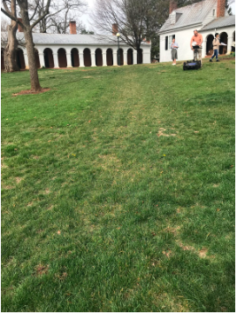
2006 aerial imagery of Monroe Hill displays a narrow pathway diagonally connecting the two major paths still existing on the site.
This narrower pathway was removed in the last six months as can be seen in visible disruption to the site via the different grass texture evident in a recent photo taken.