Documenting the Kitchen at Birdwood
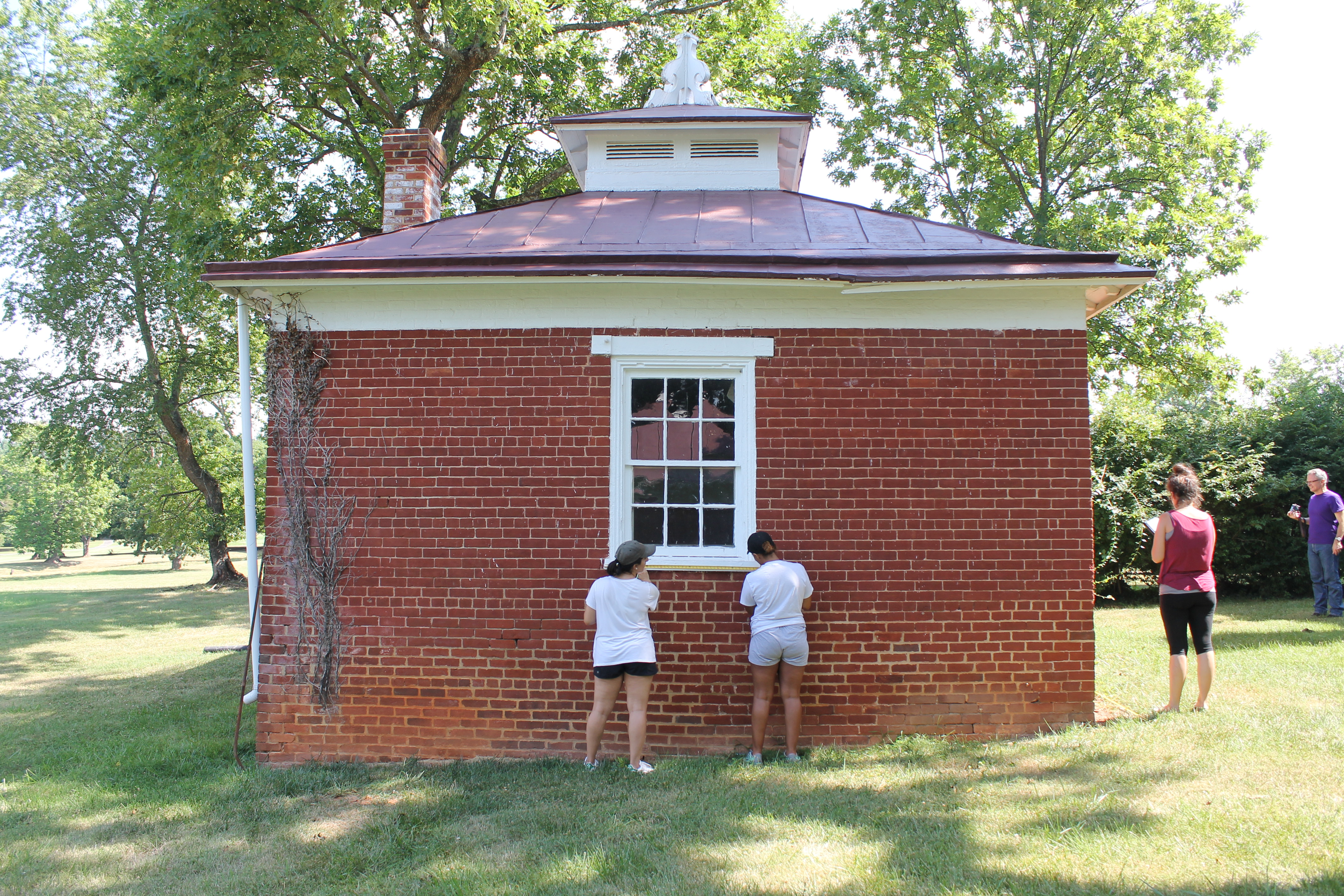
One of our class objectives was to investigate and document the outbuilding at Birdwood commonly referred to as the kitchen. A plantation the size of Birdwood would have required a sizeable kitchen space to support the large family and necessary house workers. The kitchen areas of large homes were often built as a separate structure from the main house in order to contain the sounds and smells of an early 19th century kitchen, as well as to keep any fires from spreading to the main house. The kitchen at Birdwood is believed to have been built at the same time as the main plantation house in the early 1830's and is one of the four dependencies original to the property.

In order to document the kitchen building we utilized a variety of techniques ranging from simple hand sketches to three-dimensional laser scanning technology. By using this wide array of methods, our class was able to thoroughly document the kitchen structure at Birdwood. Our goal was to get as much data and information about the kitchen as possible so that we could record the structure in as accurate and complete a way as possible. This included taking hand measurements and photographs of the site as well as creating hand sketches of the building. The class also employed aerial photography, ground penetrating radar, laser scanning, and 3D modeling software to complete the picture of the kitchen at Birdwood. Each of these methods added to the depth of our knowledge about the kitchen and contributed to our overall understanding of the building.
The first step that our class took to document the kitchen was to take photos and hand measurements of the building. Photos are very useful when referencing specific details of the building and its orientation in the landscape and in documenting the visual appearance of the building. The class wanted to get as much data as possible on the dimensions of the building, carefully measuring each surface and any additional features such as the trim on the windows. We quickly realized that the kitchen was built on uneven ground which created an obstacle in recording the height of the structure. One way to approach this was to look at the variation in the number of rows of brick, or courses, from one end of a wall to the other. If the left side of the face has four more courses of brick that the right side and a course of brick is 3 1/4 inches tall, we know that there is a thirteen-inch elevation change from one side to the other. While taking our measurements we also noticed areas where the mortar had been repaired and places where the walls appeared to be bulging outward. Taking hand measurements gave us a better understanding of the building’s construction and also gave us the information we needed in order to begin documenting the physical appearance of the kitchen.
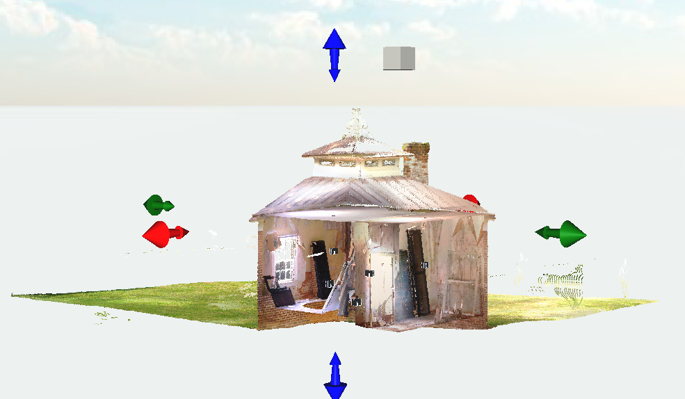
One of the practical uses for the hand measurements of the kitchen that the class gathered in our field work was to create 3D models based on the dimensions of the building. We were fortunate to have Lauren Massari from the Institute for Advanced Technology in the Humanities (IATH) teach us how to utilize advanced 3D modeling software to create a scaled representation of a building. We gained hands on experience using 3D Max to begin generating a model of the kitchen outbuilding. 3D modelling allows people to see and interact with the likeness of a building without having to actually visit the site. Modeling is also very helpful for recreating buildings that no longer exist to see what a structure would have looked like when it was still standing. In the case of our class, we wanted to apply the measurements we had taken to build a model of the building that would visually represent the data we had recorded in our field work. Using a model can sometimes be more helpful than a photograph, as it allows the viewer to experience the building from all sides and in many cases, provides a high resolution of the details of the building. Our models that we created were very basic, but a professional who is experienced with the software would be able to make a very precise representation of the structure.
The class continued to gather documentation of the kitchen in order to fill in the gaps we still had in our knowledge of the physical properties of the building. The hand measurements, sketches, and photographs we had taken combined with our 3D models of the building provided a great deal of information, but there were still a few missing pieces. From our vantage point on the ground we were unable to measure the roof structure and the cupola. We also wondered about the topographical landscape surrounding the area and how that may have impacted the construction of the kitchen and other outbuildings. Arin Bennett from the UVA Scholar’s Lab assisted us with capturing numerous aerial photographs depicting the kitchen and the surrounding grounds. His high-resolution photos further informed our documentation of the kitchen by providing images of the roof of the building and the cupola from multiple angles.

Our final investigation into the kitchen structure was using laser scanners to collect a 3D image of the interior and exterior of the building. Using a Faro Focus laser scanner, Will worked with us to take several scans of both the interior and exterior of the kitchen and then combine them into one very impressive representation of the entire structure and its surrounding landscape. The millions of points painted a fascinating picture of the kitchen in ways that our other methods of study had not. The resulting image from the laser scanning process made it possible to see inside the building and create interesting cross sections from any angle. Being able to see the entire building, both inside and out, in one interactive 3D image really gave us the big picture of the structure. It also enabled us to take measurements that would otherwise be almost impossible, such as the thickness of the walls and the height of the floors off the ground. The laser scanner image also made it easier to see and measure some of the subtle nuances of the building. The class had previously noticed that two of the exterior walls were curved slightly outward but it would have been impractical if not impossible to measure these delicate changes by hand. The point cloud created by the laser scanner makes it possible to explore such nuances further and learn more about the subtleties of the building structure that are not easily captured in more traditional methods of gathering field data.
By using this range of field methods, we were able to gain a comprehensive knowledge of the kitchen structure at Birdwood. The class worked with several experts to learn about and execute various methods of gathering data. By utilizing multiple strategies, we recorded a great deal of information and were then able to take this data and apply it to our 3D model of the kitchen. It would be beneficial to add further detail to the model, including a more complete representation of the roof construction and decorative cornice pieces. The class would also be interested to do more investigation into the interior of the building. It had clearly been altered numerous times, and we feel it would be beneficial to document the interior conditions and even attempt to uncover clues to the original configuration of the kitchen interior.